
Szczytna: Trails, Peaks and History
Accommodation in Szczytna
Szczytna lies between the Stołowe Mountains and the Bystrzyckie Mountains, on the Bystrzyca Dusznicka River. Its location combines a mountain landscape with a local history that can be traced through churches, a statue of St. John of Nepomuk and a former fort. There are also several hikes of very different lengths, as well as cycling routes. If you are looking for a holiday apartment for a stay combining nature and culture, Szczytna offers a range of themes to shape your excursions around.
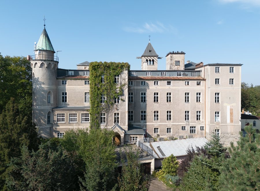
Mountain scenery and historic buildings
Szczytnik rises 589 m above Szczytna. The 19th-century Neo-Gothic castle of the Hochberg family stands on its summit. Leśna Skała is a Neo-Gothic palace on the rocky Szczytnik above Szczytna; it was built between 1831 and 1838 as a hunting residence. Its terrace offers wide views of the surrounding landscape. Here, the mountain setting takes centre stage alongside a distinctive building: visitors can discover the elevation and the architecture together as they explore the area.
Historic details also shape the character of the town. The Baroque Church of St. John the Baptist is one of Szczytna’s characteristic buildings; construction was completed in 1726. On Sienkiewicza Street, above Kamienny Potok, stands a listed statue of St. John of Nepomuk dating from 1711. A fort was built on Szczytnik between 1790 and 1795 as part of a line of fortifications. It was intended to warn Kłodzko Fortress of approaching enemy armies. Those interested in architectural history will find a variety of landmarks here: a Baroque church, a historic statue and a military installation.
Hikes of varying lengths
For a short, clearly defined mountain hike, a yellow trail leads from Szczytna to Szczytnik. The ascent is 1.3 km long and takes about 40 minutes. A longer circular route is “From Szczytna to Wolarz”: it covers 11.1 km and leads to Wolarz, which is 852 m high, in the Bystrzyckie Mountains. It starts at a historic railway station dating from 1890. The two hikes differ mainly in length and destination—from the ascent to Szczytnik to the circular hike to Wolarz.
Another option is the 14.1 km hike “To Muflon.” It begins at the junction of International Road 8 and Sienkiewicza Street, by the statue of St. John of Nepomuk. Most of the route lies within the municipality of Szczytna; the destination, Schronisko pod Muflonem, is outside the municipality. This distinction is useful for planning your hike if you want to know where the municipal boundary ends and where the trail leads.
Cycling and activities
A linear cycling route of about 50 km runs from Szczytna to Bystrzyca Kłodzka. Trains can be used for the return journey or to complete the route. A 127 km blue cycling loop around the Stołowe Mountains also runs north of Szczytna. It follows fully paved roads along the Polish-Czech border. The two options differ considerably in scope: the linear route leads to another town, while the longer loop circles the Stołowe Mountains.
Szczytna’s sports, active holiday and movement therapy centre includes three artificial turf playing fields and a high ropes course with a climbing wall. The annual Skatepiknik Integracyjny, held since 2010, includes an Olympics for preschool children. These activities complement hiking and culture with sports and a recurring annual event.
Choose Szczytna as a holiday destination
When choosing a holiday apartment in Szczytna, you can consider what you want your stay to focus on: short mountain trails, longer hikes, cycling tours or historic buildings. The transport links are also useful to know about: the DK8 national road between Wrocław and Kudowa-Zdrój passes through Szczytna, as does the railway line from Kłodzko to Kudowa-Zdrój. The routes and buildings described here can help you identify what interests you without limiting yourself to just one kind of excursion.
If you would like to discover more places: Leśna, Sienna, Kletno, Potoczek, Wójtowice, Lewin Kłodzki, Nowa Morawa and Poręba.
For the overview of the wider region: Kłodzki.

.jpg)